Deadly Floods Start Weeks Earlier Than You Think, New Ocean Map Reveals
A new map of ocean moisture sources could give forecasters extra warning time before atmospheric rivers trigger destructive floods.
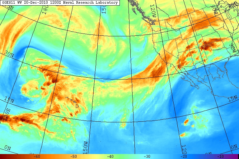
By the time a flood makes headlines, the weather system behind it has often been building for days out over open ocean, far from any coastline. A new study published in Climate and Atmospheric Science has mapped exactly where that process begins, tracing atmospheric rivers back to the specific ocean regions where they pick up the moisture that later falls as destructive rain.
Atmospheric rivers are narrow but powerful corridors of water vapour that can stretch for thousands of kilometres, carrying more water through the sky than any surface river on Earth. To understand how they form and strengthen, researchers examined more than 40 years of global atmospheric data, blending satellite imagery, weather reanalysis records and computer models to follow these systems from their origin to landfall.
What they found is that atmospheric rivers do not pick up moisture continuously. Instead, they pass through a limited number of ocean ‘hotspots’ where warm sea temperatures and particular wind conditions drive intense evaporation. Regions in the eastern Indian Ocean and western Pacific near Australia stood out as major sources, feeding systems that can go on to strike Australia, New Zealand, South America or Antarctica.
According to the research, some atmospheric rivers draw moisture from several of these ocean regions during a single journey, while others rely on just one source throughout their entire path — a pattern that could help scientists forecast how a given system will behave before it ever reaches land. Overall, these systems are estimated to carry roughly 90% of the water vapour that moves from the tropics towards the poles.
The threat becomes real once an atmospheric river reaches land and is forced upward by mountain ranges or a weather front: the vapour cools and condenses, falling as rain or snow. When a system is strong or slow-moving, that can mean days of intense rainfall, raising the risk of flooding and landslides. Past atmospheric-river floods in Australia, California, western Europe, South America and New Zealand have caused billions of dollars in damage.
Researchers say the new map gives forecasters a way to watch these ocean ‘fueling stations’ directly, rather than waiting for signs near the coast, which could translate into more warning time before a flood hits. They also caution that as ocean temperatures continue to rise, evaporation from these same hotspot regions is likely to increase, potentially making future atmospheric rivers carry even more moisture than they do today.
Image credit: Wikimedia Commons



Leave a Reply